Promote development patterns that encourage a mix of land uses, efficient infrastructure, and preservation of open space in order to support a range of housing, employment, and transportation options.
LAND USE & INFRASTRUCTURE
objective:
descriptive understanding
One way to think about a city is to consider its “urban spatial structure.” Spatial structure has to do with the shape of a city, or how it is organized on the landscape. Is it spread out or tightly knit? How are its major land use groups organized? Are industries concentrated in one general area, dispersed, or clumped in a few concentrations? Convenient access to services, cost of public services and quality of life are all examples of things that can be affected by the spatial structure of a city.
After the Manhattan Project, Oak Ridge maintained its characteristic greenbelts and compact neighborhoods, each with schools and commercial services. A key fact is that the water and sewer system was built at one time to serve 75,000 people and is in need of being replaced and upgraded. Since then, the population has declined to less than 30,000, and many of the schools and businesses embedded in neighborhoods are gone. Yet the water, sewer and electrical systems need continual improvement within annual city budget allocations.
More than half of the area within the incorporated municipal limits of Oak Ridge is owned and managed by the U.S. Department of Energy (DOE). The reservation, once about 70,000 acres is now about 33,000 acres. In that the DOE has four key sites: Oak Ridge National Laboratory, Y-12 / Consolidated Nuclear Security, Heritage Center at K-25 (East Tennessee Technology Park), and the DOE Administration Building on Administration Road in Oak Ridge. In the 33,000 acres there are areas that the Department may want to hold on to for the foreseeable future, some land that could become available for transfer into private ownership at some time, and land that might ultimately go in either direction.
Future jobs and population growth need not occur in the typical costly, sprawling pattern that has characterized growth in other parts of the region. New housing, services, and work places should be concentrated within already urbanized areas that can accommodate higher density development. Aging commercial strips, underutilized warehousing and massive, largely unused parking lots are among redevelopment opportunities that would not require major infrastructure costs, and would experience increases in property value.
Recommendations
The following list of ideas and recommended actions are intended to promote attractive and accessible development patterns that support economic vitality and sustainable growth. It is imperative to align the built environment with adequate infrastructure and services, such as water and sewer, police and fire, emergency preparedness, and community facilities. To do this, coordination of planning and implementation is critical between all City Departments and the School District administration.
- Identify specific areas, in addition to the city center, with high potential for redevelopment and infill, and partner with the Housing Authority and Industrial Development Board to create revitalization programs that attract private or partnered investment in those areas. Potential opportunities for new housing options or mixed-use development include:
- Highland View neighborhood
- East Fork Poplar Creek parallel to S. Illinois Ave
- Jackson Square
- Grove Center
- Adopt land use policies that can promote a sustainable and resilient physical environment, such as energy efficiency, water conservation, Low-Impact Development techniques to manage stormwater runoff and reduce damage and costs related to hazardous flood events, adaptive reuse of buildings, and more. Better building and site design can provide long-term cost savings and increase property values.
- Build a new water treatment facility to replace the 1940’s era structure located near Y-12, to update the system, improve water quality and efficiency, and allow better access for City workers.
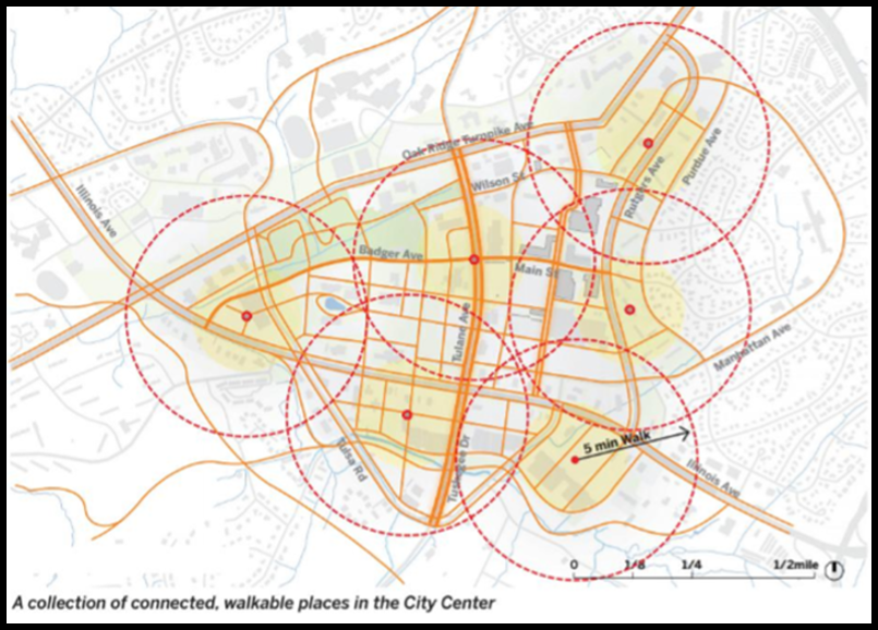
- Create a new zoning approach for the city center, to ensure compact and mixed-use development with urban design guidelines that are specific to the kind of place desired by the community, essentially based on the Oak Ridge City Center 2030 Strategy report by Skidmore Owings & Merrill (November 2018).
- Invest in the renovation, expansion, and planning for new public school facilities to better reflect the quality of education that is recognized by the community. Value in education is related to value in the health and safety of the school-age population.
- Coordinate strategic land and resource planning efforts between the City of Oak Ridge and the US Department of Energy to establish an ongoing process to synchronize planning efforts, including the future use of the approximately 25,000 acres of forested federal reservation.
- Coordinate an updated Land Use Plan and other City plans and studies with the annual Capital Improvement Program and Municipal Budget process.
- Relocate or expand fire station facilities to resolve current service needs on the east side. Continue study of a potential 5th station location.
- Explore alternative, innovative tools for analyzing local budget policies and funding mechanisms that facilitate growth and maintain the fiscal health of a full-service city.
- Prepare an analysis of land use and zoning, economic and development trends, and growth expectations and create a new Land Use Plan or more strategic “Growth and Change” Map, that projects the City’s desired parameters for physical development. This Plan should be part of a thorough update to the City’s Comprehensive Plan.
- Amend the Zoning Ordinance and Zoning Map following the adoption of a Growth and Change Map, to synchronize these regulations with the desired outcomes. Include clear performance measures and incentives that attract development.
- Explore renovation of the Animal Shelter and improve educational
efforts and humane methods to control overpopulation or neglect of animals.
Skidmore, Owings and Merrill (SOM) has been involved in the planning and design of buildings, individual sites and the layout of the city since the early days of the Manhattan Project. After the end of World War II, the firm produced the City’s first Master Plan for future development.
In 2018, a new connection was made between city and design firm. Philip Enquist, a retired principal in the firm, served a 5-year appointment as the Governor’s Chair for Energy and Urbanism on the campus of the University of Tennessee in Knoxville. Through sponsorship by the Oak Ridge National Laboratory, Mr. Enquist studied cities and the health of regions, which resulted in a focus on Oak Ridge and a report that was shared with the City, called Oak Ridge City Center, A 2030 Strategy.
The report identifies issues, opportunities, and objectives for a thriving city center. The visualizations and design concepts in the report present the kind of exploratory planning that will aid in the evolution of the emerging downtown of Oak Ridge, and contributed significantly to this plan.

big idea: EAST FORK POPLAR CREEK REDEVELOPMENT
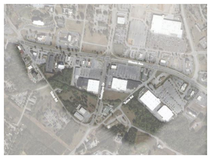
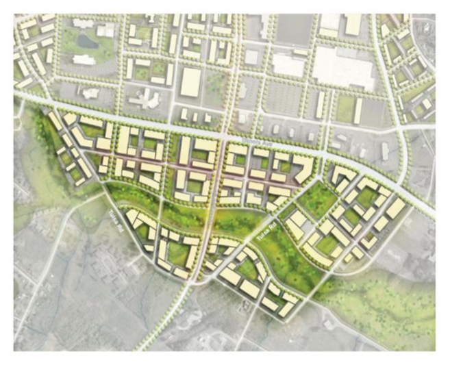
A recent study by Skidmore, Owings & Merrill (SOM), identified a major opportunity to collectively address economic development and tax base, recreation and mobility, and environmental health issues in the city center, by bringing about significant redevelopment of land adjacent to East Fork Poplar Creek. The area south of S. Illinois Avenue between Lafayette and the Turnpike, and generally behind the high-vacancy big box retail properties, holds great potential to become a new urban district.
Remediation and beautification of the waterway would create an attractive area for residential units of medium density (8-12 units per acre). Potentially hundreds of new residents in the vicinity would inspire new retail development along South Illinois, which should incorporate urban design so that buildings are placed closer to streets and sidewalks and within walking distance of other destinations rather than behind acres of underutilized parking lots. Making the creek visually appealing will offer opportunities for waterfront views, businesses, and public spaces.
An important part of the concept would be to add a greenway along the creek that links the Rails to Trails Greenway to existing bike lanes on the Oak Ridge Turnpike, to strengthen the overall network of connections throughout the city.
Existing conditions at South Illinois and Tuskagee Drive

Conceptual greenway and mixed-use development

